
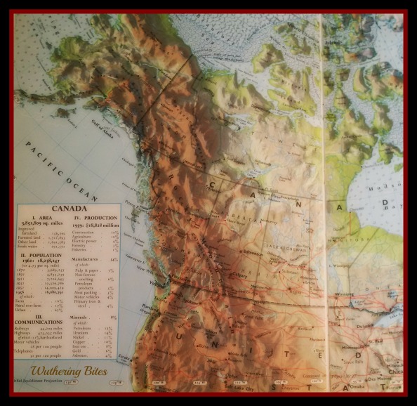
Map of Canada – 1963
When the Canadian Oxford Desk Atlas of the World dated 1963 was published, I was six years old. The first map in the book shows the land mass of Canada and the scale is one inch to 300 miles. In this atlas the islands and inlets spattering the west coast of my childhood are, like my memories, unnamed. I know now those islands grew from cataclysms and it makes sense that the route through them – the way home – is dangerous.
The old map illustrates the islands as flecks of green outlined in turquoise blue surrounded by light blue channels. The green ink spreads beyond the blue borders, the printing press as imprecise as my memories. My eye skips along the green specks as though I’m a flat stone side-angle thrown into the salt chuck and I hop island to island to reach the small black dot up north that signifies my hometown.
But it’s not that easy. There are tides to navigate. Some Islands disappear at high tide. At low tide deceptive sand bars emerge and hook the islands to the mainland and give a false sense of permanence. Tide tables fluctuate with the moods of the weather and wind and the ocean floor and the coastline. Safety cannot be guaranteed.
When I was a kid, it seemed exciting that the islands appeared unnamed, as though they’d wait for me to name them, like memories; that when I was ready to examine them they’d appear on the map ready to be read. It turns out the memories have shrunk and some have disappeared with the tides or lost in decades of coastal deluges.
I stare at the map and try to name the flecks that appear and disappear but the scale is too small and I can’t find my way. But I’m going to try.

I enjoyed reading this post. The nuanced way you’ve encouraged me to think about memories and maps and how we think about places and how to get there when we are younger – as different from what our maps look like over time – makes me smile!
LikeLiked by 1 person
Brilliant Susanne, the way you’ve summed it up. “I stare at the map and try to name the flecks that appear and disappear but the scale is too small and I can’t find my way. But I’m going to try”.
Got me thinking. Maps on faces, maps of memories….landscapes and names change, some exist, some don’t…….
LikeLiked by 1 person
Nice post, Susanne! I love maps, landscapes, the ocean, and you have covered all three!
LikeLiked by 1 person
I love how you describe the landscape and the map. Your words have a lyrical feel to them. Very soothing.
LikeLiked by 1 person
Thank you kindly! Some of the memories are soothing and others not so much. Who knows where they’ll take me?!
LikeLiked by 1 person
I love this, Susanne. The map, memories, naming: it’s all so rich with possibility. This reads like an intro…
LikeLiked by 1 person
My husband said exactly the same thing. Maybe it IS a beginning.
LikeLike
Fascinating. When I was setting cryptic crosswords I had to keep up to date with atlases that do constantly change.
LikeLiked by 1 person
You once set cryptic crosswords? Now there’s a tantalizing tidbit. Do tell more!
LikeLiked by 1 person
I spent 20 years at it – for newspapers and magazines; also a couple of books. https://derrickjknight.com/2012/07/12/mordred/ Thanks, Susanne
LikeLiked by 1 person
I was pondering memory the other day, how some memories are so vivid and how others are so faded that it almost feels like you are remembering a story you read and not something that you actually experienced. Looking forward to seeing where you go with this.
LikeLike
I heard a radio documentary on the unreliability of most memories which makes writing memoir-y non-fiction suspect all around! And yet we ache to tell our stories – real AND imagined!
LikeLiked by 1 person
So succinctly put. Ache is the word and sometimes ‘headache’ is the other word…
LikeLike
I find myself staring hard at the nameless nodules and so seeing which still exist, which are the ones that disappear and reappear with the moon driven tides. Whether those now sunk are Northern Atlantas’s. I wonder. The wonderfully tactile appearance of the colourful topography and your words, vaguely startled by the passage of time, captivate me.
LikeLike
I adore this atlas for all the gorgeous colours and how each colour relates to particular geographical forms (what’s that called?). Have you ever stood on a sand bar when the tide is coming in? There’s a sinking, Atlantian feeling!
LikeLiked by 1 person
So I have not but I’ll bet it’s quite amazing!
LikeLiked by 1 person
Great metaphor for life. I’ve heard it said that a memory is only as good as the last time you remembered it. Interesting, right? I look forward to the one’s you’ll be sharing 🙂
LikeLiked by 1 person
I’m really struggling with how to write about what I barely remember. I’ve been culling my older siblings’ memories to see if they shake anything loose but nada. We shall see what emerges with low tide.
LikeLiked by 1 person
Gosh, I don’t even recognise this as a map of Canada Susanne. It seems truncated in width and elongated in height – one can never tell about maps and reality though. I have a deep love of islands myself – the thought that some have come and gone in your life time is a worrying one, unless they were barely a metre above the sea then it would be understandable. You have set yourself a great task, have fun! I hope you will share more with us.
LikeLiked by 1 person
I had to crop the map a bit to get the focus more on the west coast. As often happens in map drawing of North America, the US gets prominence even though Canada’s land mass is larger.
I’m not 100% clear where I’m going (hence the map 😉 ) with this but it is delving into the past where memory is not always reliable.
LikeLike